SAN DIEGO — While the intensity of rain, wind, and mountain snow will vary throughout the next few days, the heaviest of precipitation are expected from Tuesday evening into early Wednesday in San Diego County.
School Closures
Due to the risk high winds pose to school busses, schools in the Mountain Empire Unified School District will be closed on Tuesday, Feb. 22.
Additionally, the Julian Union Elementary, Julian Union High, and Spencer Valley school districts have declared a snow day and will be closed on Feb. 22.
Warnings and Advisories
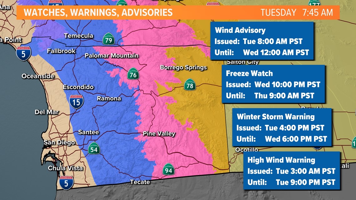
In anticipation of plenty of winter weather across the county, there are several weather alerts to be aware of. A Wind Advisory will take effect across the coastline and inland valleys with a Winter Storm Warning over the mountaintops. Snow levels will be around 4,000 feet for Monday and early Tuesday but drop near 2,000 Wednesday morning. A High Wind Warning is in effect across San Diego County mountains and deserts.
A Freeze Watch will go into effect on Wednesday night and will run through Thursday morning.

Road Conditions
The California Highway Patrol will have a check point at Sunrise Highway either at Old Highway 80 or two miles north of Old Hwy 80 on Sunrise Highway near Graffiti Rock. Officers will be checking all vehicles for the presence of snow chains including 4x4 and All Wheel Drive vehicles. Depending on road and weather conditions, State Route 79 from Descanso to Julian may also have a check point and chain control.
Chain control – chains will absolutely be necessary, and only vehicles with chains will be allowed access. The installation of chains may be required at the check point.
WATCH: East San Diego County prepares for cold weather, snow from the incoming storm
With a deepening of the marine layer, we can expect to see light showers through Tuesday morning. The cool air will linger as highs peak 5 to 15 degrees below normal Tuesday and Wednesday afternoon. Night and morning temperatures will be cold along the coast in the 40s and 30s. The big chill will be felt from the valleys to the desert with near to below freezing temperatures.
The bulk of the moisture is expected from Tuesday evening into Wednesday morning. Models show an increasing amount of rain (even moderate to heavy at times), with snow levels dropping down, and a chance for thunderstorms – similar to last week. Strong cells will be capable of producing lightning, heavy rain and small hail.

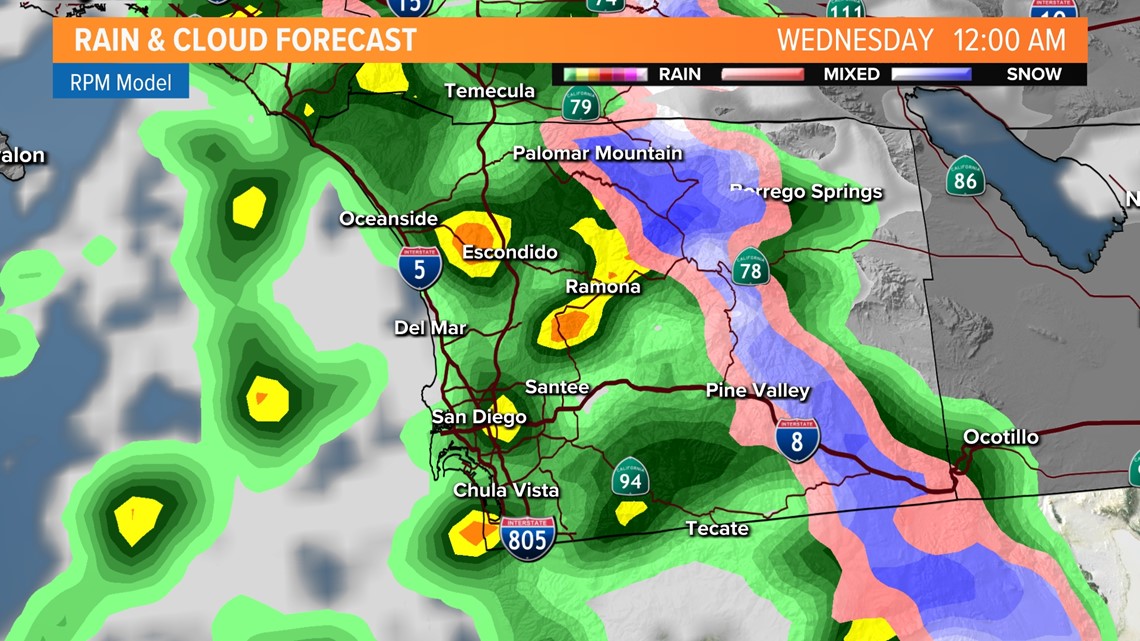
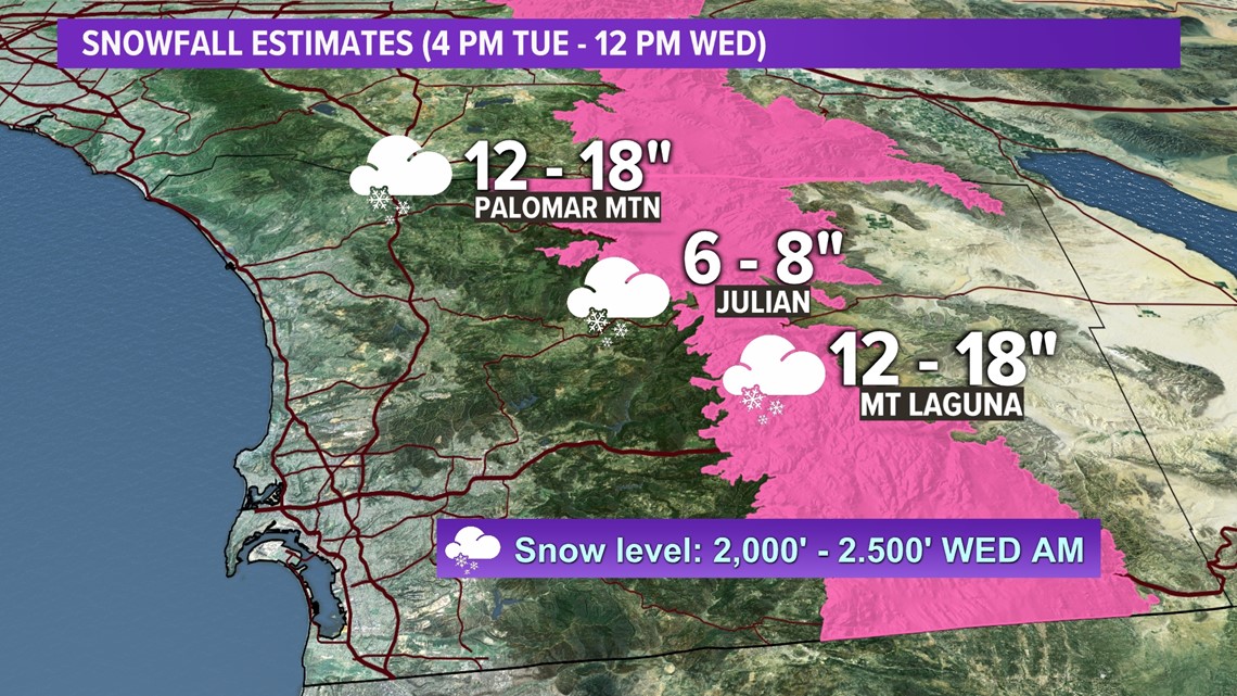
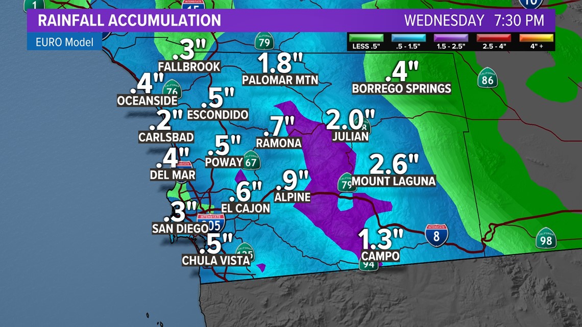
By Wednesday night, this storm could leave the county with a decent amount of rain and snow accumulation. The coastlines can expect between a quarter of an inch to half an inch over those three days. Inland valleys are looking closer to half an inch with some spots expecting slightly more -- even closer to an inch for regions like Escondido. With the plunging snow level, our local mountains will see moderate to heavy snow. Deserts could also see more than a quarter of an inch.